Wouldn't it be great if farmers could have an 'eye in the sky' that would monitor the health of their crops throughout the growing season? If everything looks good, they can enjoy the peace of mind in knowing that their chance of hitting the year's yield goals is promising. If problems are revealed, they have a chance to work with their trusted advisors to act fast — knowing exactly where to investigate gives quick, cost-effective remedies great odds.
As many of you know, this is already happening. Satellite imagery has become a crucial ‘early warning system’ to help farmers and their crop advisors carefully monitor crop health, and execute quick decisions that maximize yield.
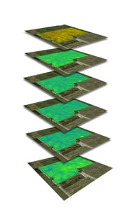 The main purpose of these vegetation maps is to allow farmers and their trusted advisors to clearly see areas in the field where their crop might be having an issue. By catching problems early, they can determine if there’s a cost-effective solution to correct the situation, thus restoring their chance of achieving a healthy yield in that area.
"When farmers ask me why early detection is so important, I explain that it's all about driving real-time actions," says Viviane Faria, Remote Sensing and GIS expert with the Trimble Ag Software product development team. "Early detection enables targeted scouting, which could include soil or tissue sampling in that exact area, or maybe even sending a drone to do a deeper dive. You can then manage the right input to recover crop health and increase yield."
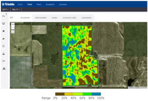
These images are even more useful when they can be viewed right on your mobile device. This can really speed up the process of detection, diagnosis, and then pulling the trigger on any remedies that might be cost-effective.
Evaluating Options for Satellite Imagery? Know These Key Considerations:
Let's look at some of the key considerations you need to weigh in order to find the satellite imagery option that is best for your farm operation:
1.) PRICE
The main drivers of imagery price are frequency and spatial resolution. Frequency means how often a satellite will take a picture of your farm. Spatial resolution is the minimum area seen by the satellite from space.
As frequency and spatial resolution increases, the cost of image also increases. Always ask for the satellites specs when you are evaluating your options.
2.) FREQUENCY AND CLOUD DETECTION AT FIELD LEVEL
 These satellites use sunlight to see objects on Earth, including plants. The issue is that they cannot see anything under clouds. Frequency of images is important in making sure you get enough coverage of your field, despite cloud cover.
"Keep in mind that the more cloud-free image you have, the more efficient it becomes to monitor your fields," Faria says. At the end of the day, the usefulness of satellite imagery depends on getting reliable, consistent crop health imagery maps you can count on. A crucial point to understand is the importance of tracking these crop health images on a regular basis.
3.) SPATIAL RESOLUTION
The third consideration is spatial resolution, which is related to the pixel size. A pixel is the minimum area of your field seen by the satellite. Finer spatial resolution allows you to see more details in the image. However, you need to balance spatial resolution and equipment precision as well as the purpose of your application. Not all applications in agriculture requires a super fine resolution.
Since higher resolution will cost more, you always need to determine if the image improvement you’re going to have is worth the extra money spent for the application you need.
4.) ATMOSPHERIC CONDITION AND SOIL BACKGROUND NOISE
Finally, the last key consideration to remember is the importance of calibration. For example, Crop Health Imagery is powered by PurePixel, which leverages a proprietary algorithm to analyze multiple sensor inputs and reduces soil background noise that misleads vegetation index values. The end result? Calibrated vegetative index maps that can be used to compare crop health at each step of the growing stage.
Calibration is important is because the amount of sunlight that gets to the Earth varies throughout the day and throughout the year. If this correction is not done, you cannot compare one image to another. It’s always good to check if these corrections have been done by your imagery source provider.